Este estudio presenta un análisis de los sistemas convectivos de mesoescala (SCM) de verano que se desarrollaron en el noroeste de México durante los intensos episodios de El Niño Oscilación del Sur ocurridos de 1997 a 1999. Los resultados del análisis de datos geoestacionarios indican que el mayor número de SCM se asociaron con el episodio de El Niño de 1997, y tuvieron un periodo activo más prolongado. Durante el episodio de La Niña de 1999 se observó un menor número de SCM, los cuales se desarrollaron durante un periodo activo menor. La ocurrencia de SCM se vincula con la localización de la cresta y las anomalías anticiclónicas a alturas geopotenciales de 500 hPa y 200 hPa, respectivamente.
This study presents an analysis of the summertime mesoscale convective systems (MCSs) that developed in northwestern Mexico during the strong ENSO events of 1997-1999. From the analysis of geostationary data, results indicate that the largest number of MCSs was associated with the 1997 El Niño event throughout a longer active period. During the La Niña event of 1999 fewer MCSs were observed, which had developed over a shorter active period. The occurrence of MCSs is linked to the location of the ridge and the anticyclonic anomalies at 500 hPa and 200 hPa, respectively.
The North American monsoon is a summertime climate phenomenon that occurs in northwest (NW) Mexico and the southwest United States (Adams and Comrie, 1997). Mohr and Zipser (1996) found that NW Mexico is one of the areas with more occurrences of mesoscale convective systems (MCS) in the world and observed many of them along the Sierra Madre Occidental (SMO), which produced around 75% of the rainfall in this region (Lang et al., 2007). Furthermore, Douglas et al. (1986) and Farfán and Zehnder (1994) found that synoptic conditions like the location of the 500hPa ridge and the presence of easterlies were important to the formation and movement of convective systems in NW Mexico, which is a Mexican region heavily influenced by El Niño-Southern Oscillation (ENSO) (Salinas-Zavala et al., 2002).
Valdés-Manzanilla and Barradas (2012) studied MCSs in NW Mexico during the North American Monsoon Experiment (NAME) and found that their formation was related to midlevel easterly winds, 500 hParidges and inverted troughs. They also found that wind shear had a great importance in the organization of MCS convection.
Given that the climate of NW Mexico is influenced by ENSO, this study focuses on the role of ENSO on modulating the spatial and temporal distribution of MCSs during the extreme ENSO events that occurred between 1997 and 1999.
2Data and methodsInfrared satellite imagery obtained from the Geostationary Operational Environmental Satellites (GOES) receiving station, located at the Instituto Mexicano de Tecnología del Agua (Mexican Institute of Water Technology), was used to determine if a cloud system was an MCS. These GOES-8 images had a format of 8 bits and 750 × 512 pixels with temporal and horizontal resolution of 30min and 4 × 4km, respectively. The area of study was slightly different to that used by Valdés-Manzanilla and Barradas (2012), covering from 20 to 35° N latitude and from 105 to 115° W longitude. The study period spanned from June to September of three consecutive years, 1997, 1998 and 1999. A cloud system was considered an MCS only if it retained a cloud area of at least 250km limited by a temperature threshold of –54 °C (219 °K), for no less than three consecutive hours, as in Valdés-Manzanilla and Barradas (2012) and Valdés-Manzanilla et al. (2005).
Reanalysis data (Kalnay et al., 1996) were used to study interannual variations in synoptic conditions for the period considered. These data were obtained from the Climate Diagnostic Center of NOAA, covering an area bounded by 15 to 40° N latitude and 75 to 125° W longitude.
Rainfall data for 1998 and 1999 were obtained from the product 2B43 of the Tropical Rainfall Measuring Mission (TRMM) (Liu et al., 2012). Data were not available for 1997 because the database was initiated in January 1998.
An active period of MCS formation was defined as when an MCS remained at least two consecutive days or two MCSs occurred in one day, while an inactive period was defined as when there were two days without the occurrence of an MCS, as in Parker and Johnson (2000).
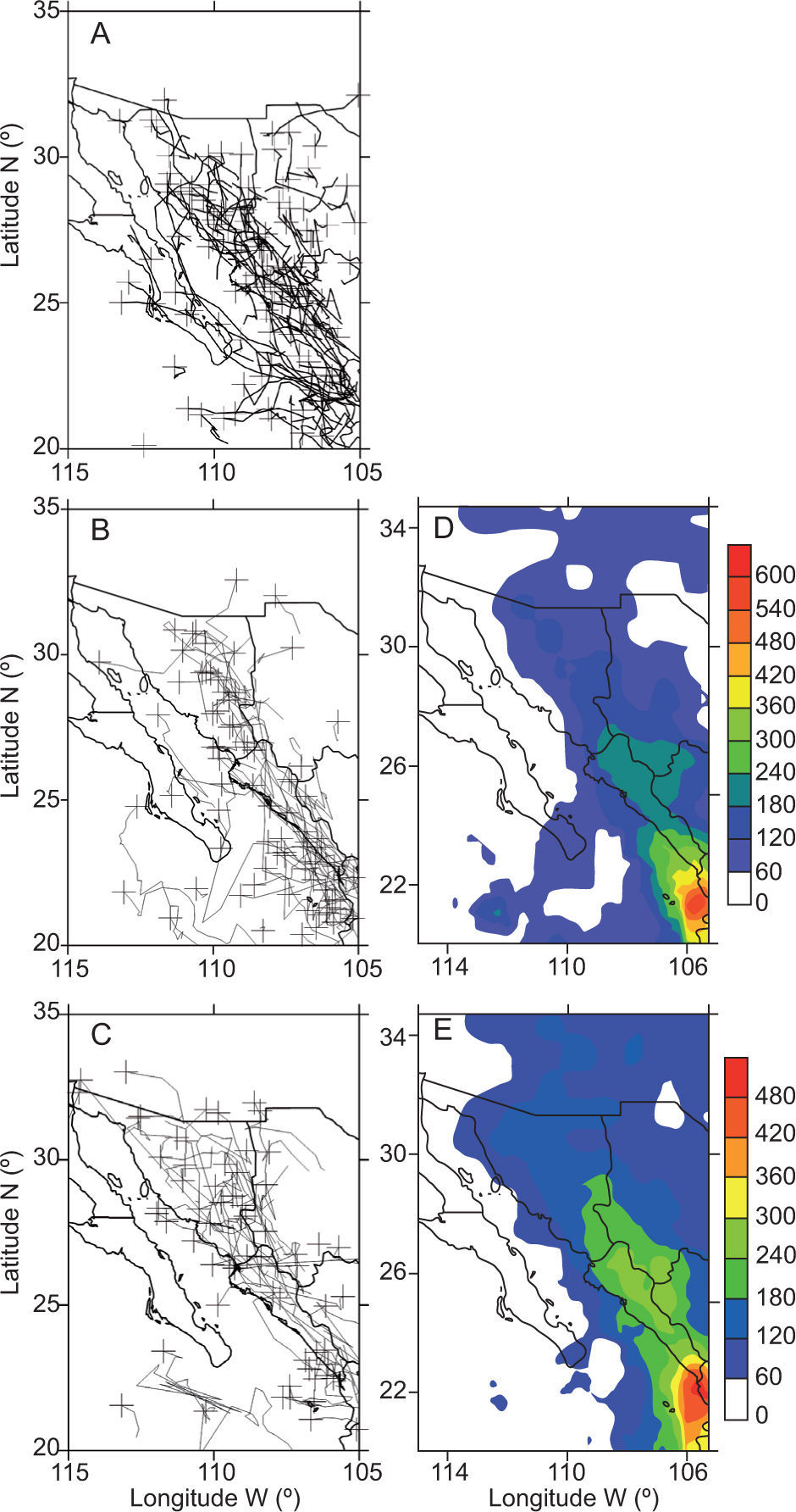
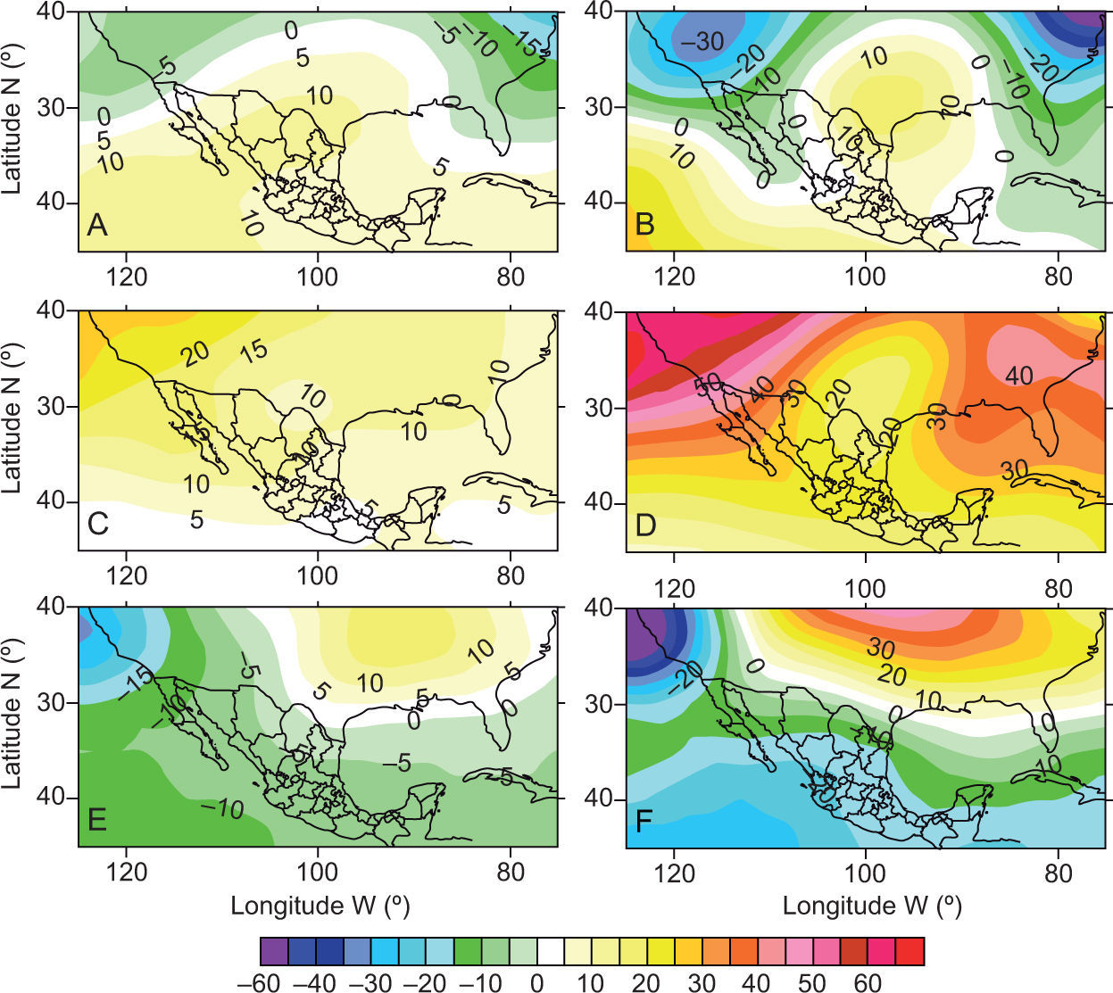
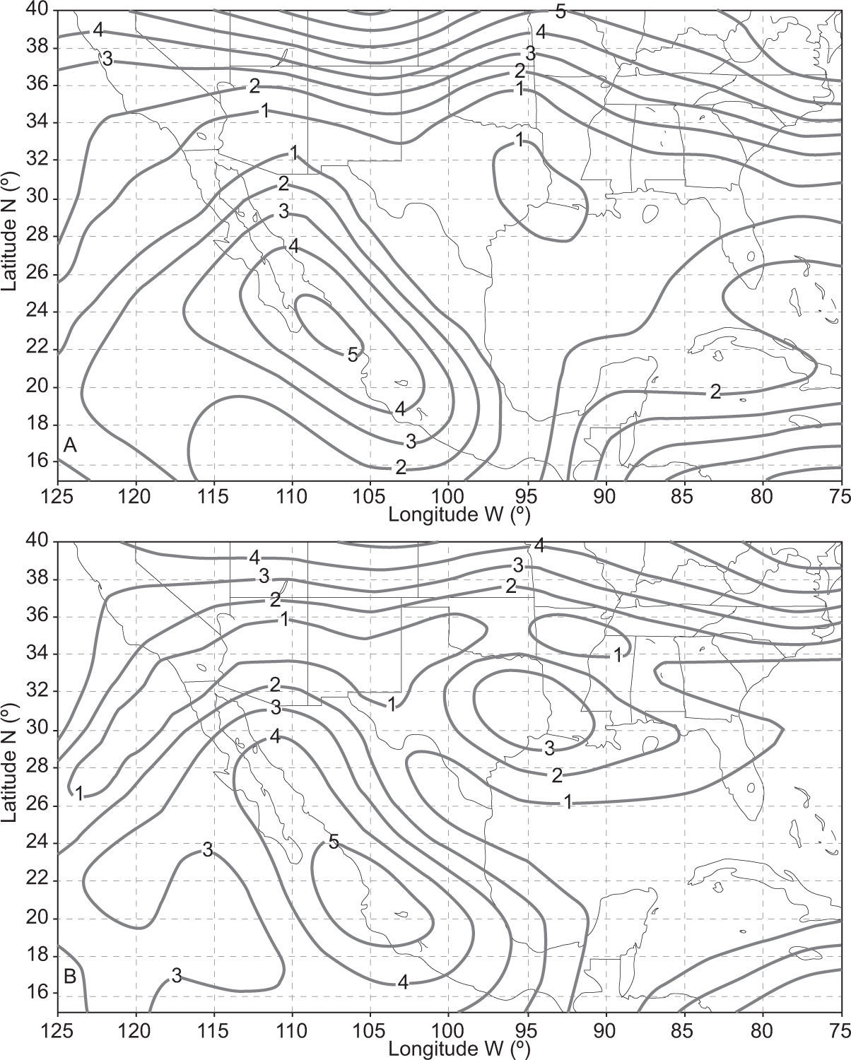
3Results and discussionTable I shows that 119 MCSs occurred during 1997 in NW Mexico, a number 36% greater than their three-yr average (87.3%). The spatial distribution of all the MCSs observed between June and September 1997 (Fig. 1a) shows that MCSs were mostly concentrated in the southern portion of the study area, which includes the southern Baja California peninsula, the coastal plain, the Sierra Madre Occidental and the northern Mexican plateau. Few MCSs occurred in the US-Mexico border. From the synoptic point of view, there was a ridge at 500 hPa during these months in 1997, which was located further south and was more intense than normal (Fig. 2a), and a high-pressure area at 200 hPa (Fig. 2b) also stronger than normal. Furthermore, midlevel easterlies were also observed that have been associated to MCS occurrences in this region (Douglas et al., 1986; Nesbitt et al., 2008;Farfán and Zehnder, 1994). The same synoptic condition occurred during 2004, a weak El Niño year, which resulted in the high number of MCSs observed (Valdés-Manzanilla and Barradas, 2012). The midlevel wind shear was moderate during 1997 and more concentrated in the southern portion of the area of study, which helped to increase MCSs formation in this region, but not in the US-Mexico border (Fig. 3a).
MCS tracks in NW Mexico during (a) 1997, (b) 1998 (b), and (c) 1999, where the plus (+) signs mark the MCSs final tracks positions. (d) Accumulated rainfall (mm) for July and August 1998. (e) Same than (d) but for 1999. Data for (d) and (e) were obtained from the product 2B43 of the TRMM satellite (TRMM data are available since 1998).
Anomalies of the long-term mean (1981-2010) of geopotential heights (in meters) for July and August from the NCAR-NCEP reanalysis data, in the following levels and years: (a) 500 hPa, 1997; (b) 200 hPa, 1997; (c) 500 hPa, 1998; (d) 200 hPa, 1998; (e) 500 hPa, 1999, and (f) 200 hPa, 1999.
Castro et al. (2001) found that the position of the 500 hPa ridge is influenced by the ENSO phenomenon. Therefore, it is likely that the large number of MCSs observed during 1997 was due to an indirect influence of ENSO through a favorable position of the 500 hPa ridge, in lieu of a direct influence of ENSO through the increase of sea surface temperatures (SSTs) normally associated to El Niño. Furthermore, the 500 hPa ridge also strengthened the land breeze phenomenon found by Negri et al. (1994) in the southern Gulf of California, through easterlies that reinforce offshore winds, influencing formation and movement of MCSs in this region.
Table I shows that 79 MCSs occurred during 1998, a transition year between El Niño and La Niña, which is a smaller number (–10%) than the average. The spatial distribution of MCSs during 1998 was similar to that of 1997, except in the USA-Mexico border (Fig. 1b), and rainfall was more concentrated in the southern portion of this region (Fig. 1d). Furthermore, the 500hPa ridge was located further north and was stronger than normal (Fig. 2c), and the monsoonal high pressure at 200hPa was also stronger than normal (Fig. 2d), which might have influenced the occurrence of MCSs in this region as was suggested by Valdés-Manzanilla and Barradas (2012) and Nesbitt et al. (2008).
There were only 64 MCSs during 1999 (Table I), which was a La Niña year, about 27% of the three-yr. average. The season started with a large number of MCSs developing in June, reflecting perhaps an early onset of the North American monsoon, which has been associated to La Niña events by Englehart and Douglas (2006). The spatial distribution of MCSs during 1999 showed the smallest number of these and less rainfall in all areas with respect to other years, specifically in the southern Gulf of California (Fig. 1c, e). On the other hand, a great number of MCSs occurred in the USA-Mexico border, located in the northern portion of the study area, which experienced a wet monsoon (Cavazos et al., 2002). Furthermore, the 500 hPa ridge location was closer to the northeast and stronger than normal (Fig. 2e) without a monsoonal high pressure area at 200 hPa (Fig. 2f). This synoptic pattern influenced notably the occurrence of MCSs, particularly in the southern portion of the study area, due to an unfavourable wind direction from the southwest, as was also found by Valdés-Manzanilla and Barradas (2012). The midlevel vertical wind shear was also moderate during this year, but its location moved toward the northern portion of the study area, which favoured an increase in MCSs formation of the US-Mexico border (Fig. 3b).
The average number of days in the active and inactive periods of MCSs formation was 62.3 and 21 days, respectively (Table II). The summer of 1997 had the greatest number of days in the active periods (74), 18% higher than the three-yr. average, probably due to the presence of midlevel easterlies that have been associated to active periods (Valdés-Manzanilla and Barradas, 2012). On the other hand, this year had the smallest number of days in the inactive periods (18), apparently due to the occurrence of midlevel southwesterlies that have been associated to inactive periods (Valdés-Manzanilla and Barradas, 2012).
List of active and inactive periods of MCS occurrences during 1997, 1998 and 1999. The length of the periods (in days) is shown in parentheses.
| Year | Active periods | Inactive periods |
|---|---|---|
| 1997 | 24 Jun-18 Jul (25) | 19-21 Jul (3) |
| 22 Jul-15 Aug (25) | 16-23 Aug (8) | |
| 24 Aug-9 Sep (17) | 10-11 Sep (2) | |
| 12-13 Sep (2) | 14-18 Sep (5) | |
| 19-23 Sep (5) | ||
| 1998 | 1-6 Jul (6) | 7-9 Jul (3) |
| 10 Jul-29 Aug (50) | 30 Aug-5 Sep (7) | |
| 6-8 Sep (3) | 9-15 Sep (7) | |
| 16-17 Sep (2) | ||
| 1999 | 23 Jun-3 Jul (11) | 4-5 Jul (2) |
| 11-18 Jul (8) | 7-10 Jul (4) | |
| 21-25 Jul (5) | 19-20 Jul (2) | |
| 1-14 Aug (14) | 26-27 Jul (2) | |
| 19-29 Aug (11) | 29-31 Jul (3) | |
| 7 Sep (1) | 15-18 Aug (4) | |
| 13-14 Sep (2) | 30 Aug-2 Sep (3) | |
| 4-6 Sep (3) | ||
| 8-12 Sep (5) |
The summer of 1999 had the smallest number of days in the active periods (52), 17% lower than the average, and also the highest number of days in the inactive periods (28), 33% higher than the average.
4ConclusionsThe results of this study suggest a large influence of the 500 hPa ridge and the monsoonal high-pressure area at 200 hPa in MCSs formation in NW Mexico during the ENSO events of 1997-1999. It is recommended that more ENSO events should be studied to corroborate these results, maybe through an automatic algorithm to detect MCSs in this region. Furthermore, it is necessary to increase the frequency of soundings and upgrade regional radars to the technology of dual-polarization to continue studying the influence of cloud physics, and kinematic and thermodynamic conditions in MCSs formation in this region with complex orography.
The author wishes to thank two anonymous reviewers for their suggestions, which improved this study greatly.


