Se analizaron datos aeromagnéticos de la región Akonolinga–Mbama, con la finalidad de determinar la geología de subsuperficie de la zona. La interpretación de los datos disponibles, en forma de un mapa aeromagnético residual, muestra a esta vasta zona como magnéticamente tranquila, y las zonas complejas no se correlacionan con la geología de la superficie de la región.
Dentro de esta zona magnética tranquila una zona negativa alta, anómala, alargada y circular parece significar la intrusión de una roca plutónica en las formaciones metamórficas de la región. Se utilizaron el análisis espectral y la modelación dimensional de 2 y medio (2½ -D) para determinar la profundidad de los cuerpos que lo causaron y analizar las rocas de origen a lo largo de tres perfiles que cruzan las zonas en estudio. Se obtuvieron modelos de las intrusiones graníticas de diversas zonas, lo cual parece significar algunas fallas poco profundas a lo largo de las zonas de contacto. Esto nos permitió delimitar el margen norte del Congo Cratón, con lo cual distinguimos las formaciones cratónicas de la faja Panafricana plegada. Parte de la faja se ha extendido sobre la parte norte del Congo Cratón en Camerún.
Aeromagnetic data of the Akonolinga-Mbama region are analyzed in order to elucidate the subsurface geology of the area. The available data in the form of a residual aeromagnetic map is interpreted as a vast magnetically quiet region, and complex zones which do not correlate with the surface geology of the region.
Within the magnetically quiet zone, a high negative circular elongated anomaly zone seems to represent an intrusion of a plutonic rock into the metamorphic formations of the region. Spectral analysis and two-and-a-half dimensional (2½-D) modeling are used to estimate the depth of the causative bodies and determine the source rocks along three profiles crossing the suspected areas. Models from various zones of granitic intrusions are obtained, thereby proposing some shallow fault lines along zones of contact. This permits us to mark out the northern margin of the Congo Craton, thus enabling us to distinguish the cratonic formations from the Pan African fold belt. Part of the belt has been thrust over the northern portion of the Congo Craton in Cameroon.
The Akonolinga-Mbama region is situated in the central-south area of Cameroon (Central Africa) from latitude 3º15’N to 4º30’N and longitude 12º E to 13º E. This region, with an average altitude of 700m, occupies the southern plateau of Cameroon and is made up of a monotonous landscape, mainly of gently undulating dome shaped hills of convex slopes and few rocky domes with concave slopes.
The area of study is part of the Precambrian of central and southern Cameroon which shows many geological features of different ages and varying petrographic characteristics (Tadjou et al., 2009). In the Pan-African domain, geological studies (Toteu et al., 2004) reveal that the region was formed during the Pan-African event in latest Proterozoic to earliest Palaeozoic by convergence and collision between the Congo Craton to the south and the Pan-African mobile belt to the north.
Gravity and audiomagnetotellurics studies by Collignon (1968), Ndougsa et al. (2003), Tadjou et al. (2009), 1992Manguelle-Dicoum et al. ( & 1993), Mbom Abane (1997), and Meying et al.(2009) have shown that the limit of the Congo Craton is characterized by a network of faults which traverse the region of study. The exact position of the limit of the Congo Craton has not yet been traced (Ndougsa et al., 2002 & 2003). The objective of this study is to use the aeromagnetic data of the Akonolinga-Mbama region to investigate the major tectonic features and the subsurface geology, and to delimit the Northern limit of the Congo Craton.
Geology and tectonic settingThe area of study (Figure 1) is part of the Pan-African-Brazillian belt made of belts which were rejuvenated during the Pan-African orogeny about 550 Ma ago (Vicat, 1998; Djouka et al., 2004; Toteu et al., 2004). It is largely intruded by Neoproterozoic granitoids of Pan-African age emplaced from early stage of deformation to late uplift stage of the evolution of the Central African Fold Belt (CAFB). The region is in the southern portion of the Pan-African mobile domain that shares a boundary with the Congo Craton. It is composed of granite-gneissic rocks and those of the Precambrian intermediate formation (Vicat, 1998). This intermediate formation constitutes the Yaounde group formed of the Ayos-MbalmayoBengbis series which dip to the north and merge with the Yaounde series without any lithological break. The Ayos-Mbalmayo-Bengbis series are is mainly composed of schists and recrystalized quartzites. This schist and quartzite complex is a belt trending E-W, and covering about 1500km (Vicat, 1998). The composition is made up of chlorite-schist, micaschist with or without garnet, gneisses and slates with numerous veins of quartzite. The Ayos-Mbalmayo-Bengbis series contains the same metasedimentary composition as the Yaoundé series, but metamorphosed and deformed at different structural levels (Olinga et al., 2010).
Geological map of Cameroon with foliation trends (After Toteu et al., 2004).
The Yaoundé series is comprised of low to high grade garnet bearing schist, mica-schist, disthene, quartzite and gneisses metamorphosed under medium to high pressure metamorphism reaching the granulite facies (Toteu et al., 2004; Vicat, 1998). The schists and gneisses are interpreted as neoproterozoic epicontinental deposits related either to an intracontinental distensive environment or a passive margin. Structurally, the Yaoundé series are made up of juxtaposed rock units which are interpreted as a large nappe that is thrusted southward onto the Congo Craton (Toteu et al., 2004). The AyosMbalmayo-Bengbis series (Figure 1) dips to the north and merges with the Yaoundé series without any major lithological break (Tadjou et al., 2009).
The schist seems to have been formed from clay or limestone sediments. The mica-schist of this region is thought to have been formed on top of the chloride-schist. The primary minerals of the schist include muscovite, biotite, quartz and garnet, disthene, rutile and ilmenite as secondary minerals (Ndougsa et al., 2003; Paterson et al., 1976). The granites are of the calco-alkalinic and leucocratic type with heterogeneity in mineralogy.
As regards the tectonics, the region has a complex and uneven tectonic structure which is described to have resulted from orogenic movements of the Pan-African basement (Tadjou et al., 2009). Although no clear evidence of the tectonic nature of the region is observed at the surface, it is worth noting the foliation and migmatization of the region (Figure 2). The arcuate foliation is regarded to have resulted from deformation of the underlying Congo Craton (Toteu et al., 2004; Mvondo et al., 2007). The schist and mica-schist are relatively folded (Olinga et al., 2010).
Simplified geological map of the area of study (Adapted from Nnange, 1991; Ndougsa et al., 2003).
The aeromagnetic data in Cameroon was collected over a total surface area of 168,365km2 (Paterson et al., 1976). This area was divided into six regions of which the area of study is found within the Akonolinga region. The survey was carried out at a nominal terrain clearance of 235m which was monitored by a radar altimeter with an accuracy of+20m. The line spacing of the flight was 750m but the real distance rarely went above 1km and the flight direction was N-S.
The data for this study was in the form of a residual magnetic anomaly map. This map was redigitized using the MAPINFO 7.5 package and was then gridded producing a new residual aeromagnetic anomaly map of contour interval 50 nT plotted (Figure 3) with the use of the Surfer 8.0 package.
Description of Residual MapThe residual aeromagnetic map (Figure 3) of this region is characterized by moderate amplitude anomalies ranging from about -300 to 200 nT and trends in the E-W and NEE-SWW directions. Based on the features of the contours, the map can be partitioned in to a smooth magnetic (around and north of the latitude 4º N parallel) and the magnetically complex (south) anomaly zone.
We also observe zones of magnetic lows, some of which exist as circular negative elongated anomalies similar to those whose forms could indicate an induced magnetization on rocks with high magnetic susceptibility. The negative anomaly zones are along the migmatites and schist formations of the geological map.
Within the smooth magnetic anomaly zone, there exist a vast magnetically quiet zone which covers the granites, part of the schists, migmatite and gneiss of the region. Nnange (2000) suggests that the granites, schists and gneisses of the area are probably homogeneous in terms of magnetic character and were probably derived from rocks with little or no magnetite. The map shows in some areas (North) high positive anomalies. The gradient zones and traces of suspected rock intrusions within the region suggest the existence of suture zones within the Akonolinga-Mbama region (Figure 4).
Method of analysisThe data set for the quantitative analysis was obtained from profiles drawn across selected areas. The values of the anomalies and the distances obtained from the respective intersections of the profile and the contour lines constitute the principal input in the data modeling.
A spectral analysis code written based on the Spector & Grant (1970) and Bhattacharyya & Leu (1975) mathematical analyses, was used to determine the depth of the anomaly source. The mathematical analysis converts the data from the space to the frequency domain.
With the aid of a 2.5D modeling software mag2dc (Cooper, 2003), the chosen profiles were modeled to analyze the subsurface structure of the region. The mag2dc software uses the Talwani (1965) type algorithm to calculate the anomaly.
The value of the geomagnetic field, the inclination and the declination of the region, the bearing of the profile and the reference height (235m) at which the data was collected are used as secondary input. In the present case, the inclination and declination angles of the ambient field were taken as -19.89 ° N and -5.88 °E, respectively (2.5°N, 14°E) in the center of the region at the date of January 1970 according to IGRF. The observed data curve and the theoretical one fitting is obtained by building a geometrical body.The depth from the spectral analysis, and physical parameters defined by the operator are compared to form a good fit. The physical parameter for this study is the magnetic susceptibility of the various rock types obtained from Telford et al. (1990) and Robert (1982). According to the geology of the area under study, the rocks found in the region were depicted to have their magnetic susceptibilities ranging from 0.0001 to 0.058 cgs. Hence the mean susceptibility of each of the rocks derived from the geology was used for the initialization of the modeling. Knowledge from previous geophysical analyses also served as bases for the modeling. The geometrical parameters such as the shape, the width and the height of the bodies were defined while modeling the profiles.
ResultsSpectral AnalysisThree profiles P1, P2 and P3 were chosen and drawn on the residual aeromagnetic map (Figure 5). These profiles were drawn with a North-South orientation and traversing through the suspected area on the map.
Profile P1 covers a length of 111.0km. It has its origin at latitude 3º30’ N and lies parallel on longitude 12º6’ E up to latitude 4º30’N. This profile runs through Zoa and Akonolinga, the nearest localities to the profile to the west. From the south, the profile cuts through the mica-schist, migmatite, quartzite and lastly the mica-schist at the north of the region.
Along the profile, we have a region of high negative anomalies that create a high gradient with the positive anomalies of the north. This gradient zone and other traced zones along the profile are the areas of interest.
Profile P2 runs from latitude 3º15’ to 4º30’ N. It lies parallel along longitude 12º28’48” E and covers a distance of 138.75km. The profile cuts across with Bengbis and Mbang to the west, and Ayos and Ndele to the east. This profile passes through the schist, mica-schist, migmatite and gneissic formations from the south to the north of the geological map. At the south of the profile, there is a vast zone of negative anomalies which suggests a change in magnetic susceptibility. There is also a highly suspected zone of an intrusion about 4º N. The region with circular negative elongated anomalies creates a high gradient with the high positive anomaly zone towards the North. This profile is made up of two troughs and one crest with some having sharp peaks. This is as a result of varying magnetic character of the bodies along the profile.
The third profile lies along the parallel of longitude 12º46’48” E and runs from latitude 3º15’ to 4º30’ N. It covers a distance of 138.75km and traverses between Messamena and Mbama. The profile cuts across the schist, mica-schist, migmatite and gneiss of the region. It runs from the negative anomaly zone in the South to the positive anomalies ranging from around Messamena up to the North.
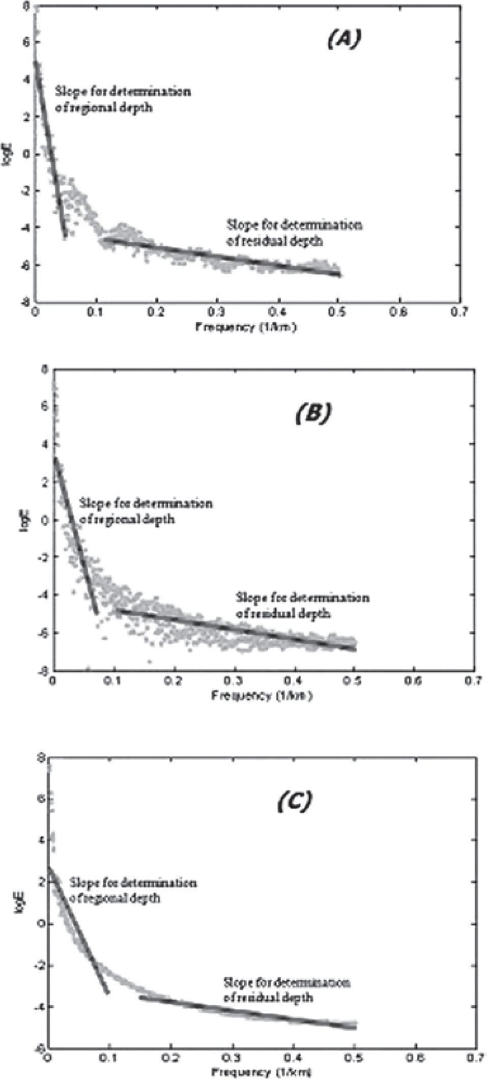
The depths of the anomaly sources (Table 1) were calculated from plots of the log of the energy spectrum versus the wave number of the residual anomalies (Figure 6). The depths obtained from the slope of the curve represent the average depth of the top of the anomaly sources. The calculation of the error for the depths was also included in the computer code. The mean least square method used, integrates the fact that the error should not be more than 10% of the depth calculated (Nnange et al., 2000). The regional depths represent the far away or deeper sources which are considered as anomaly sources of long wavelength. The residual anomaly depths serve as one of the constraints for the modeling that follows.
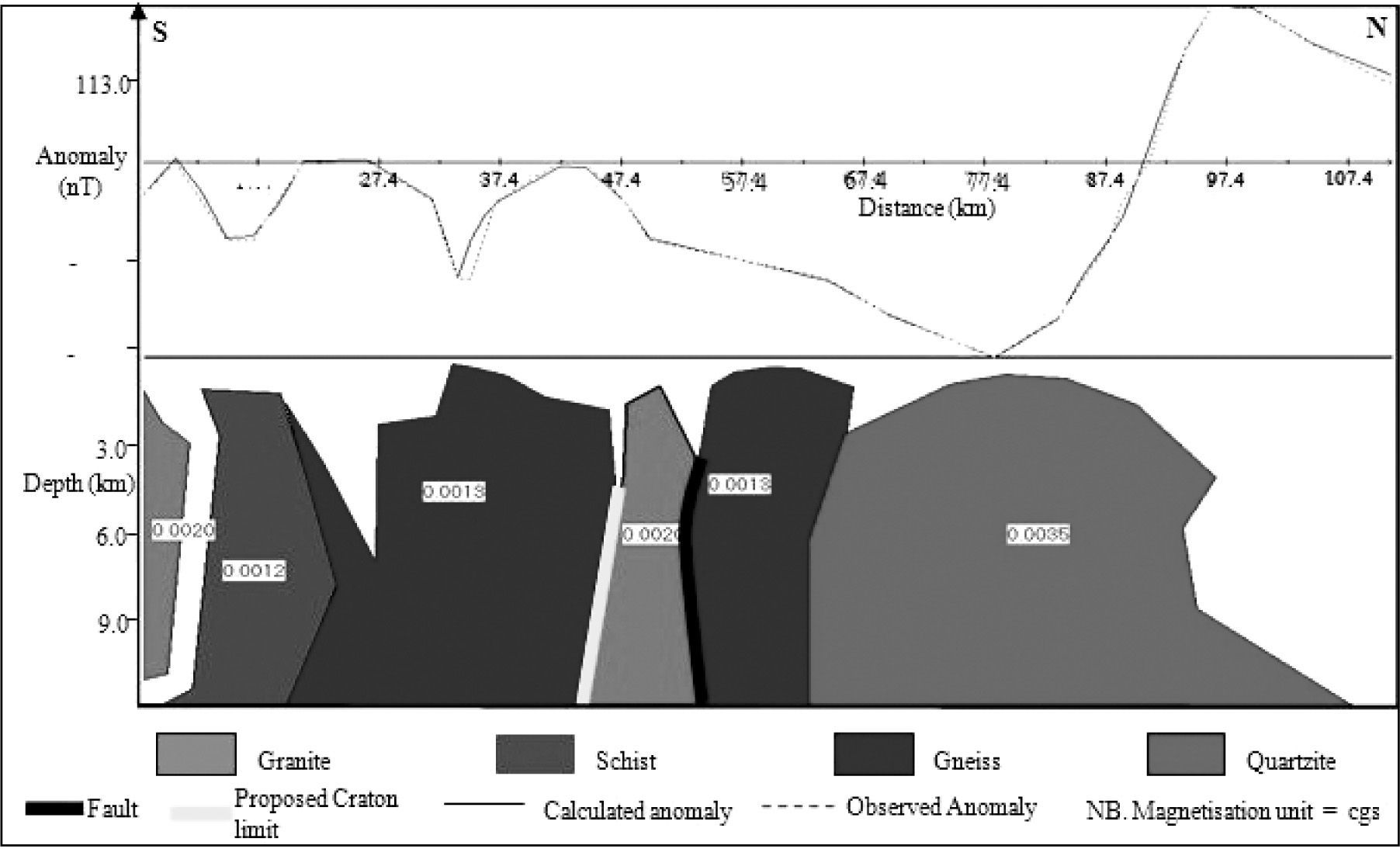
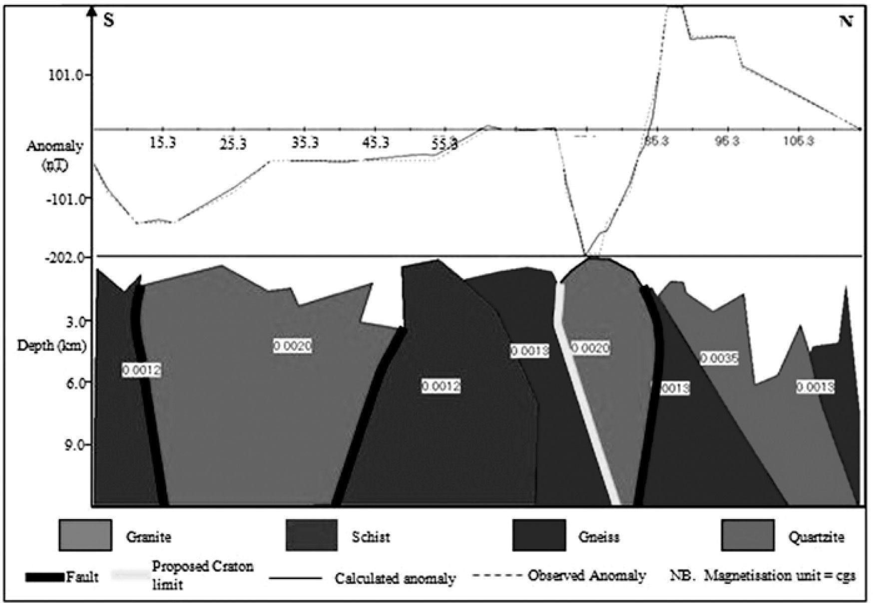
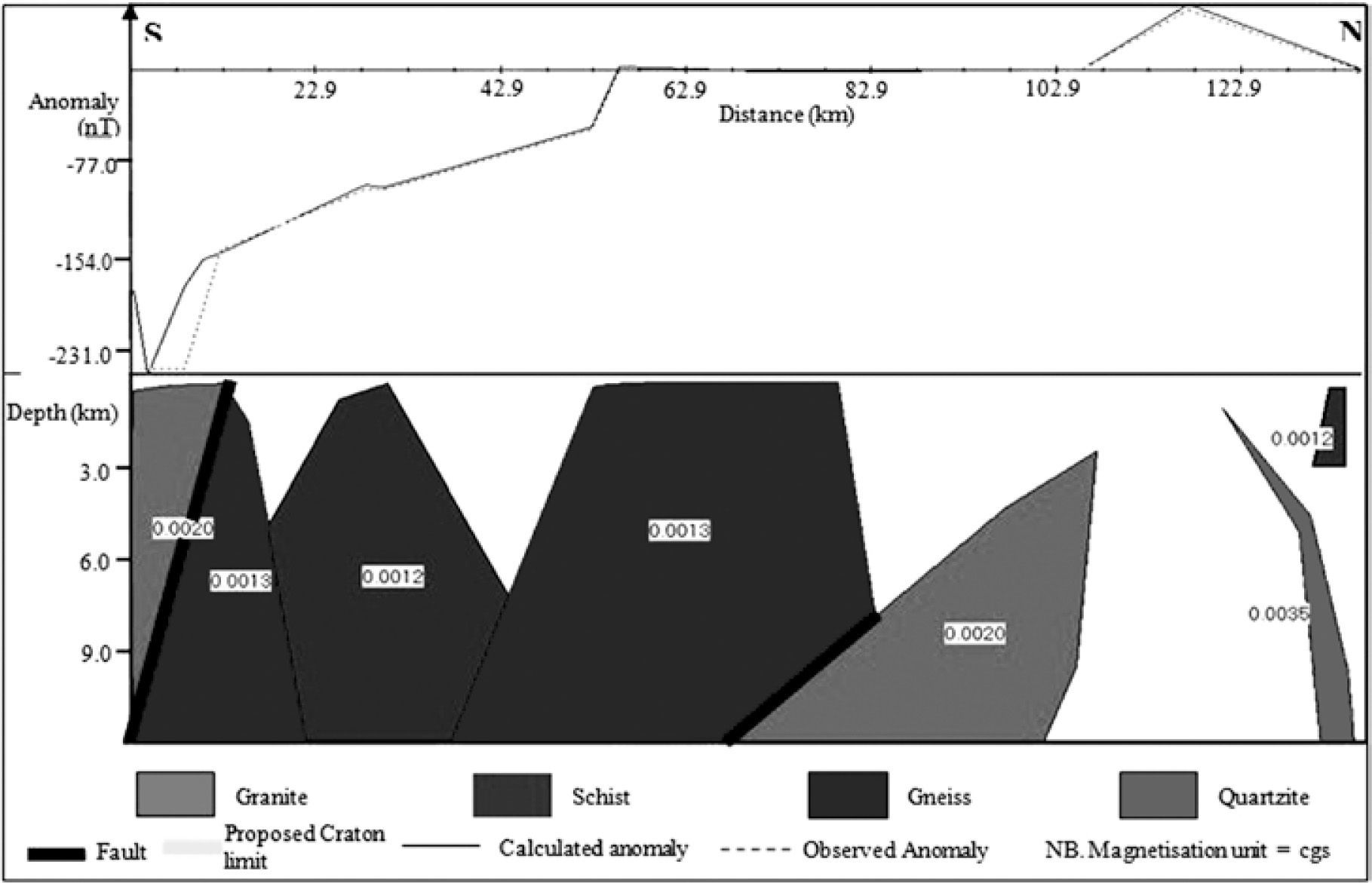
The various profiles consist of troughs and crests. These profiles correspond to the models in figures 7, 8 and 9 respectively. The models of these profiles consist of various bodies which are responsible for the observed anomalies along the profile. The models consist of the quartzite, gneiss, schist and the granite formations which lie beneath the rock formations described by the geology. From the three models, we observe the plutonic intrusions in a region which is actually known as a highly metamorphic zone.
In regard to profile P1, the positive and negative anomalies at the north of the anomaly map are due to the quartzite rock mass whose formation is probably from the metamorphism of sandstones. These positive and negative anomalies are probably because the body can be considered as a dipole. There is also the gneiss formation which is found under the migmatite of the Zoa locality. The model is constituted of different rock units that are emplaced according to the anomaly of the area. At the south of the profile, we have the schist, gneiss and the granitic formations which are responsible for the negative anomalies within the complex region around latitudes 3º30’ N, 3º39’ N and 3º45’ N respectively. As stated by Paterson et al. (1976) the schists are found beneath the mica-schist although the results from the model do not clearly differentiate if the schists are of the chlorite schist or not. Lastly, there is the granite that separates the two gneissic formations hence metamorphic-plutonic contacts. We have the granite-gneiss contacts. These contacts are found about 47km and 53km respectively from the southern edge of the profile. The granite formation is probably a result of the uprising of magma along a zone of fissure resulting to a granitic intrusion. The magma probably originated from a magma chamber of which the fissure could have extended hence creating a passage for the magma. These contact zones represent buried faults. They are located between the Mengueme and Akonolinga localities. These are similar to the results obtained from the study of gravity data by Ndougsa et al. (2003) where faults were located along the Mengueme-Akonolinga axis.
The model of profile P2 (Figure 7) is made up of schist, gneiss, and quartzite and granite rock formations. Many are all in the interior of the crust with none reaching the surface as indicated from the spectral analysis. Along the model, we have two granite intrusions. These intrusions probably resulted from the crystallization of magma rising through the zones of weakness that must have extended up to a magma chamber deep in the lithosphere where the temperature and pressure allow the rock to exist in the molten form.
From the anomaly map, the granite formations are located along zones of negative anomalies along the profile. This includes the circular elongated negative anomalies that lie on the parallel of latitude 4º N which from the model represent a granite intrusion. This intrusion is in between two gneissic formations while the other granite intrusion found at the south is in between the schist formations. The schists and gneisses are metamorphic rocks that were formed under different temperature and pressure conditions. The granite-gneiss contacts are located between Mengueme and Ayos and they represent zones of weakness, hence proposing faults within the regions. The granite-schist contacts also represent faults and are located on the north and south of Bengbis. These faults are shallow faults in the crust.
Profile P3’s model (Figure 8) is characterized by eight bodies representing different rock formations based on their structural and physical properties. This comprises metamorphic rocks; schist, gneiss and quartzite, and a large granitic rock. The negative anomaly zone at the south of the profile is as a result of the schist, gneiss and quartzite formations. The schist is sandwiched by two gneiss rock masses. Along the profile where there is the magnetic quiet zone, we have a large mass of gneissic formation which lies beneath. This gneiss shares a boundary with the granite rock mass. This gneiss-granite contact represents a fault along the profile and it is around the parallel of latitude 4° N. This contact is situated just above the Mbama locality located on the geological map. To the north of the granite formation, there exist a quartzite and a schist rock masses.
The white patches on the three models represent undifferentiated rock units which are not the cause of the observed anomalies. They are rock units with no magnetic character.
DiscussionForward modeling of magnetic data can have many models developed from the profiles. In order to obtain a model that reflects the subsurface structure, one has to consider certain parameters that would limit this uncertainty. As part of the constrains, the spectral analysis has been used to determine the average depths of the top of the anomaly sources. It is observed that the depths vary between 300m and 450m from the surface of the earth.
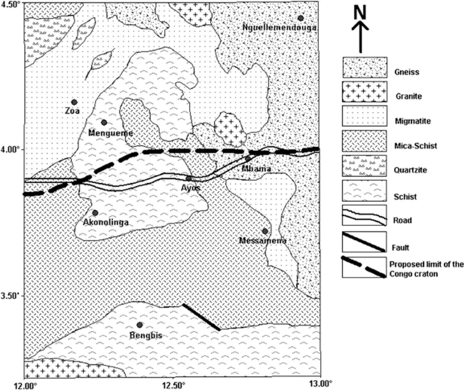
The three profiles drawn parallel to each other and their respective models, put to evidence a series of metamorphic and plutonic rocks. The granite formations of the profile P1 model (Figure 7, about 50km from the southern edge), profile P2 model (Figure 8, about 75.3km from the southern edge) and profile P3 model (Figure 9, about 95km from the southern edge) both lie almost along the parallel of latitude 4º N. This is within the transition zone between the Congo Craton and the Pan African domain. The granitic formations probably resulted from the uprise of magma through the contact zone between the Pan-African and cratonic domains, thus keeping the Pan African domain to the north and the Congo Craton to the south. Therefore tracing out the south contacts of these granitic formations (Figure 10) indicate the northern margin of the Congo Craton. Hence with respect to this limit we have the northern limit of the Congo Craton traced out on the geological map (Figure 11). The present results are in accordance with those put in evidence by Meying et al. (2009) in the Mbama, where a deep seated fault has been identified by the AMT analysis using the combination of Bostick and classical approaches (Meying et al., 2009; Ndougsa et al., 2011). In the regional scale, the structural facts identified by the study are in accordance with the results obtained by Ndougsa et al. (2002 & 2003) in the interpretation of gravity data, and the audiomagnetotelluric 1D linearized inversion & 2D forward modeling (Ndougsa et al., 2011).
ConclusionThe purpose of this study was the correlation of the magnetic data with the surface geology and the tectonics, and to determine the subsurface geology of the Akonolinga-Mbama region. In this regard, the qualitative analysis of the vast varying anomalies of the region highlighted that the anomaly sources originate from the interior of the crust. This was also suggested by spectral analysis of the data. A series of buried faults were depicted by the gradient method and areas of interruption of leveling of anomalies. Various areas of granitic intrusions were observed from the modeling. Fault lines have been identified from qualitative analysis. Based on geological data, some of the proposed faults turned out to be variations of magnetic susceptibilities of metamorphic rocks.
The present results are in agreement with gravity studies in adjacent areas which highlight a reseau of faults oriented W-E (Ndougsa et al., 2002 & 2003; Basseka et al., 2011; Shandini et al., 2010 & 2012), and the audiomagnetolluric data analysis that puts in evidence a secondary fault line with SW-NE general trend (Ndougsa et al., 2011 & 2012).
From the results in this work, the geophysical limit of the Congo Craton (Figure 11) is located around the parallel of latitude 4º N which is slightly extended to the North relative to the known limit of the Craton that appears on the surface of the Earth (Figure 2). We find that, part of the Pan African domain lies on top of the Congo Craton.
We are grateful to Professor R. J. Gordon Cooper, School of Earth Sciences, and chairman of the Geophysics group at the University of Witwatersrand for letting us use his 2.5D magnetic modeling and inversion program.


